The Grid and the Territory: Discussing What Comes After the Map with William Rankin
Tools like GPS and Google Maps are so embedded in most people's lives today that they can hardly seem worth remarking upon. Want to get from "Work" to "Home"? Simply open up the preset path into your smartphone, and the app of your choice will be glad to show you—or rather, a large blue dot—its path through the maze of streets, subway junctions, and bus lines that separate you from home.
Few people, in 2016 at least, would think about using an actual paper map to navigate from A to B. Most of the information about the other parts of your city beyond your path home are simply irrelevant to you at that particular moment, and what matters most is the accuracy of your GPS-reliant device as it guides you and the blue dot home. Not least from the perspective of the directionally challenged, the advent of GPS and similar devices just seems like the latest chapter in a history of ever-improving (because ever more accurate) mapping technologies that allow users to track moving points in space.
But as our most recent guest to the Global History Forum, William Rankin, shows in his recently published book, After the Map: Cartography, Navigation, and the Transformation of Territory in the Twentieth Century, such a Whiggish account of modern mapping is itself far from accurate. It may be true that mapping accuracy improved over the course of the twentieth century. But such an obvious statement fails to say anything about the kinds of geographic knowledge that were produced over the same period. It also overlooks the story of how the kinds of tools used to generate said cartographical knowledge changed over the twentieth century.
If we accept the GPS beacons embedded in our smartphones—or guided missiles—as the exponent of "progress," we risk overlooking how differently (and not just "better") GPS's relationship to territory and space is from those of earlier world-mapping technologies. After the Map seeks to provide, then, not just a technical history of different mapping tools over the twentieth century. It provides an analysis of how shifts in tools engendered shifts in what Rankin dubs geo-epistemology: "not just what is known about the earth, but how it is known— and how it is used."

The story that Rankin, an Assistant Professor of History at Yale University, explores in After the Map (published with the University of Chicago Press) is thus a crucial intervention into more macro debates among historians about the importance of territory and territoriality throughout the twentieth century. It is a story of how printed maps on paper—once the sine qua non of military operations, with some fifty maps printed per British and American soldier during the 1940s—became less and less relevant in the face of new coordinate systems, radionavigation, and ultimately GPS over the course of the century. It is, in short, a story that encourages readers to go from thinking about maps merely as illustrations, or tools of centralizing political authority, to seeing them as a crucial tool through which makers and users were rethinking the meaning of concepts like territory and sovereignty. In order to discuss some of these questions, Toynbee Prize Foundation Executive Director Timothy Nunan recently spoke with Rankin about After the Map.
We begin our discussion with a discussion of Rankin's path to the historical profession. Mapping, he notes, played no special role in his childhood outside of Chicago. When he went to university (to Rice), it was to study engineering and architecture. There, part of his technical education encompassed training in drawing, and when he took a class at Rice on the history of cartography, he was spurred to begin making his own maps. Following graduation, Rankin worked at an architectural firm for approximately a year. This was followed by another stint working at an experimental physics laboratory. "It was only by talking to some of my professors from architectural school," he explains, "that I began thinking about the history of science."
This struck Rankin as a novel idea. "I never knew history of science was something you could do, and it was certainly nothing that I had studied in college." Yet neither architecture nor physics had felt like optimal fits since graduation. Rankin began investigating history graduate programs, but he was accepted to Harvard to pursue graduate studies in both the history of science as well as the history of architecture. "I had been steeped in history while an undergraduate, since I had taken courses on the history of art, the history of architecture, and so on. But it was not until, perhaps, my early twenties that I realized that my style of thinking was historical. This didn't come out of being exposed to academic history, or being a history major," says Rankin.
Arriving in Cambridge, MA, Rankin worked with the historian of science Peter Galison. Much of Galison's own work emphasizes the role of scientific tools and instruments as a kind of thinking unto themselves, and Rankin notes that many of his reflections in the introduction to After the Map bear traces of that influence. But beyond Galison and another advisor, Antoine Picon, Harvard at the time of Rankin's studies was not a hub for digital history scholarship or the history of cartography, and Harvard had long ago abolished its geography department. Yet being lodged in two departments at once helped him keep his eye on broader questions, encouraged him to engage with critical theory, and opened up spatial history as an interdisciplinary method. And his earlier explorations into mapmaking as a practice between the academy and the public had, in the meantime, blossomed into one of the Web's most successful cartography sites, Radical Cartography (www.radicalcartography.net). Radical Cartography had originally, Rankin notes, been envisioned as a side project—apart from and not integrated into his graduate work—but over time, he gained the confidence that he possessed both the critical tools and cartographic toolkit to make a useful contribution to discussions about the history of mapping.

The path to the dissertation that became After the Map, however, was not so straight as the path charted on a gridded map (of which more soon). His initial dissertation prospectus aspired to write an intellectual history of infrastructure—a term, he notes, whose current meanings only date from the mid-20th century (both in the original French and in English). "I thought that a history of infrastructure would get to questions of engineering and territory, but the more I looked, the more it pointed me to the history of economics." While Rankin continued to work on mapping through Radical Cartography, he increasingly realized that the infrastructure project was not where he wanted to go. Hence, approximately a year and a half into his ostensible dissertation project, he decided to "pivot 90 degrees" to begin working on the technologies that play a central narrative role in After the Map.
We ask Rankin if he has any generalizable tips to offer to current or future graduate students based on his own research experience. He offers two. One, which isn't just meant for those working on cartography, is simple: "collect as many maps as you can." Unlike books, he notes, most university map libraries will only allow users to work with a single map at a time, and maps almost never circulate. But in his experience, just as with books or other textual evidence, his most productive engagement with maps has come when he has been able to work with multiple sources at once. If something looks good, he advises, take a photo—or download it, or scan it—in order to work with it later. The goal should be to amass a large digital collection that's tailored to your own topic and interests. This can be great for research and writing, and it's hugely helpful for teaching.
Second, however, Rankin cautions students away from the predetermined assumption that archives contain the key to all knowledge. After the Map does rely on significant forays into archives in France, Canada, the United States, and the United Kingdom, including both state archives and private papers. But for Rankin, the most useful sources he worked with often turned out to be the trade journals of the engineers involved in the three major projects at the core of the book. While one could easily spend months, if not years, scouring the archives of the International Civil Aviation Organization (in Montreal) or the National Oceanographic and Atmospheric Administration (outside of Washington, D.C.), the point is that top engineers for these institutions published in semi-trade journals when they wanted to announce to the profession that they had accomplished something novel. Understanding that there was not a direct line between difficulty of source access and the usefulness of said sources—however contrary to the legends historians tell about themselves—was a crucial intellectual step to make.
Having explored the intellectual biography behind the writing of the dissertation, we dive into the meat of Rankin's book itself. One of the core macro-level historical discussions that After the Map seeks to contribute to has to do with how we understand the twentieth century. As the introduction to Rankin's book explains, one could argue that the twentieth century marked the victory of territorializing processes. The century saw the fragmentation of all of the old colonial empires into territorial nation-states; what's more, Rankin notes, virtually all of the new post-colonial states that were created were formed along existing administrative boundaries. If capturing and annexing territory had formerly numbered among the core components of European geopolitics, by the end of the twentieth century a number of treaties—such as the 1933 Montevideo Convention, the 1975 Helsinki Accords, and treaties concerning potential German claims to Central Europe—focused instead on preserving existing borders. Not only that, but treaties covering the use of airspace, continental shelves, and Arctic space all stressed the centrality of states' territoriality.
At the same time, one could just as easily advance an interpretation of the twentieth century centered around globalization and the increased importance of transnational, non-territorial forces. Accounts like those of Charles S. Maier, or that of Michael Geyer and Charles Bright, emphasize the 1970s as a moment in modern history when the geographies of global capitalism began to exert a stronger effect on "regimes of world order" than did states or international organizations. Recent accounts of U.S. foreign policy, too, emphasize the 1970s as a moment when the United States was able to recast itself as a distinctly kind of "post-territorial" empire, able to exert hegemony not through brute force of conquest and annexation but through "nonterritorial hegemony."
How to reconcile these two narratives? For Rankin, part of the answer came through engagement with scholars of critical geography who contested the tension between "network" and "territory" often embedded into sweeping claims about the master theme or trend of the twentieth century. Fewer, however, had engaged with the actual technologies whose histories would have to be integrated into critiques of how territory was reconstituted throughout the century. Rankin's task then became, in his words, "not just looking at the history of particular devices, but trying to understand a new way of thinking." Engaging attempts to actually represent and manage territory offered the key to intervene into the debates in both global history and critical geography.
After the Map enters this debate with two related arguments. One is that there was never "any clean dichotomy between the hardening of territory and the debordering of globalization. The very same technologies that were developed to make borders more permeable have also been used to make them more stable and enforceable." While the twentieth century was, as his case studies show, marked by a turn toward making the globe universally legible through grid-based coordinates and GPS, these projects were advanced by large, powerful states—primarily the United States. Similarly, looking at the projects Rankin examines also dissolves any easy affinities between states and territory and markets and post-territory: as he notes, grids and GPS "were often developed in tandem with private corporations and enthusiastically embraced by a wide range of 'nonstate' users, domestic and foreign alike."
The second intervention of After the Map is more conceptual. While Rankin concedes that the 1970s were replete with important changes, it is problematic to conceive of the decade as the alleged pivot away from an earlier moment imagined as primordially territorial. "From the point of view of geographic knowledge," Rankin explains, "the major shift of the twentieth century was thus not a transition from national to planetary, but from one worldwide political-geographic framework to another." The 1940s, he argues, were a crucial turning point in "global" thinking from the point of view of geographic sciences. But the "globality" of this moment is not primarily in contrast to the national, but to the ideal of the international that was embedded in many prewar mapping projects.
Crucially, however, even long after this turn towards the global, territory remained very important. "Both the national/international space of the early twentieth century and the global/regional space of the late twentieth century were equally territorial," he explains. While it may be true that the importance of national jurisdictions compared to global networks did decline, Rankin stresses that it is crucial not to mistake national jurisdiction for territory. Systems that monitor the phone traffic and metadata of cell phone users worldwide, for example, may certainly be global in that they monitor activity beyond the boundaries of, for example, the United States of America. But such operations monitoring suspects in Pakistan or Afghanistan are undeniably interested in space and the management and monitoring of territories (even if these territories are conceived of not just as the national jurisdiction of Pakistan, Afghanistan, or elsewhere). Rather than territory being abolished, Rankin instead sees the twentieth century as marked by the emergence of "new kinds of territories: territories defined as frameworks of points—neither a block of space nor a network of flows—that organized knowledge in new ways and facilitated new kinds of intervention and new kinds of governance."
Rankin is aware that these might seem like rather abstract claims. In order to make the argument more concrete, After the Map is organized around three large projects that neatly illustrate the turn from an international vision of mapping that reinforced national jurisdiction to what Rankin dubs the "pointillist" logic of GPS, which instead challenged borders of all kinds. In particular, Rankin examines one project in each of the three principle branches of the mapping sciences: the International Map of the World (cartography); Universal Transverse Mercator (geodesy); and GPS (navigation).
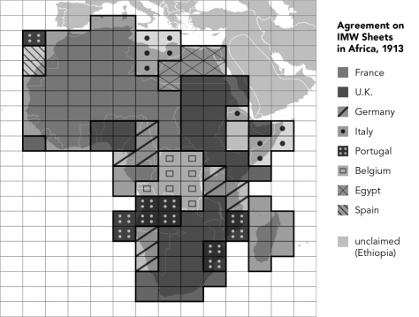
The logic of the first of Rankin's triad of projects, the IMW, may be the most familiar and approachable for non-technical readers. Maps of the world per se were nothing new—think of the age of exploration—but the IMW is best understood, Rankin says, through "the ways geographers themselves saw it in the 1890s." We ask him to elaborate. "By the 1890s," Rankin explains, "the Age of Exploration was clearly over, and cartographers saw their sister disciplines like geology and astronomy defining themselves through collaborative projects that would, they thought, serve to finalize their knowledge—for example, having observatories around the world work together on a hugely ambitious multi-decade sky survey." Entrepreneurial geographers like the University of Vienna professor Albrecht Penck argued that the time for standardized maps of the world, all at the scale of 1:1,000,000 and bounded by lines of latitude and longitude, had come. The idea was to create a base map of geographic knowledge at a more detailed scale than had ever been done—all the while formalizing geography's status as a real science.
Yet in spite of the lofty academic ambitions of Penck and his colleagues, the international network of cartographers inevitably had to turn to states in order to produce new knowledge. "This wasn't something that the instigators behind IMW had necessarily sought, or wanted. This wasn't a story, then, of cartographers hatching a conspiracy to enforce state control." Immediately prior to World War I, most of the states of the world—not just the US and European empires, but also Japan, China, and most of Central and South America—had been enrolled into this project. But the project, argues Rankin, became authoritative not just in a scientific but also in a political sense, since countries were tasked with mapping their own territories and the surrounding areas (as determined by the standardized sheets of the IMW). "The government of Egypt," as Rankin puts it, "might not necessarily care about mapping their western border with Italian-controlled Libya, but the internationalizing impulse coming from elsewhere encourages them to do so, lest they lose control over their own mapping." The IMW, in short, was not a grand plan hatched by states, nor was it a centralized effort by one state or one academic society to map the entire world.
Rather, notes Rankin, "it was about process," whereby decisions about mapping in Tanganyika or Panipat were subject to international treaties signed in London. Similarly, when private societies like the American Geographical Society or individuals like the Swedish explorer Sven Hedin made excellent maps of territories in Latin America or Central Asia, these maps were forcefully deemed "provisional" within the logic of IMW, since they had not been carried out by their respective governments. Only national governments had the proper authority to carry out the mapping of IMW squares, the logic went, so maps of "their" regions had to be considered provisional until carried out in a politically legitimate way.
Granted, in reality, the hierarchies of world politics of the day were what mattered. These "provisional" maps were often prized for their quality and used to settle international boundary disputes, and little was made of the vast internal territories of "civilized" states like the USA or Australia that had not yet been mapped. "The most pressing need was for the uniform mapping of continents that would not otherwise be mapped. Producing maps of Latin America, Africa, or colonial Asia—or even central Europe—was perhaps illegitimate, but it was also seen as a gracious service to the international community." The IMW very much reflected this civilizing logic. The pride that American geographers took in assembling their "provisional" sheets of the Amazon spoke more to a belief in the civilizing power of systemic geographic knowledge than the actual needs of anyone in the Amazon itself.
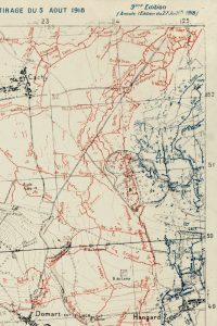
By the late 1940s, however, the lofty goals of the IMW were increasingly out of touch with actual mapping practice. Even the idea of a universal map had come to be seen as less than useful, since specialized professional audiences needed maps specific to their uses. And while the colored shading and symbolism of the IMW made it an attractive base map in theory, it didn't address the new needs of aviation or other tasks requiring precise calculation. Even during the First World War, for example, what artillery divisions operating in the trenches really needed was a way to precisely aim at targets out of their sight. The careful politics of the IMW was simply irrelevant; instead what was crucial was being able to aim weapons at particular angles and knowing that those angles would connect them with the points at which their targets were located. As Rankin notes, the geographic questions that people were asking were gradually shifting. "Instead of trying to say 'What does the terrain look like?' it became more, 'How do I know very precisely the distance between myself and my target?' This is a kind of full-scale knowledge that you just can't get through a paper map, or even through latitude and longitude."
The technology that responded to these needs—and a core pivot in After the Map—was the grid. During the First World War, gunners could not use latitude and longitude coördinates to aim, and even a hypothetically perfect map, if printed on paper, would inevitably warp over time, making it useless (not to say clunky) to use in conjunction with cannons and compasses. Grid systems instead overlay locally bound (not relative to the Equator or Prime Meridian) coordinate systems over relatively small areas, and the projection is adjusted in such a way that the grid can provide very, very high accuracy for calculating angles and distances between any two points. Instead of trying to produce a miniaturized God's-eye view of the battlefield at some arbitrary scale, grids strove to create a perfect 1:1 index of reality, and the grid—not a representational map—would become the primary space through which soldiers could orient themselves.
This shift to grid-like thinking might be confusing to grasp for the uninitiated. Indeed, mentions of a 1:1 scale map might cause readers to think of short stories by authors like Lewis Carroll and Jorge Luis Borges, in which fanciful kings and rulers task their cartographers with creating a 1:1 map of their kingdom. The task predictably ends in failure, since any 1:1 representational paper map would simply reproduce the world itself. These stories, notes Rankin, are often cited as if to highlight the hubris of cartography and the failure of representational projects.
"And yet," Rankin notes, "this is exactly what cartographers were doing by creating grids. Cartographers themselves spoke in these terms – 'we're creating a 1:1 map.'" Rankin notes that the real lesson that readers should draw from the Borges tale is a different one: "The key point in the Borges tale is that the 1:1 map is made of paper, and so it takes over the entire world. But thinking of managing space at a scale of 1:1 isn't such a fanciful venture—it just means thinking in terms of coordinates rather than paper."
The project of expanding and globalizing grid systems soon became a crucial strategic task. The shape of the earth meant that a grid projection for a chunk of the Western Front might not work if applied to territories deep into Germany. Hence, one crucial task for early grid-makers was to arduously calculate how to calibrate and connect different grid maps with one another. Such secrets were, of course, guarded jealously. Possession of high-precision grid data for an enemy country could make it susceptible to long-distance artillery properly calibrated to connect one grid with another.
By World War II, this problem took on another dimension. In World War I, reminds Rankin, much of the fighting had been concentrated along Germany's flanks. But coordination of complex naval maneuvers and military aviation operations in World War II could mean coordinating actors everywhere from Dresden to Singapore. Several countries developed patchwork systems to cope, but it was obvious that a unified system would offer great advantages. Immediately after the war, the United States stood alone in possessing both the motivation and the technical means to develop such a system.
The solution the US Army embarked upon was the so-called Universal Transverse Mercator system. UTM divides the globe into sixty north-south grid zones, each using a Transverse Mercator projection so that there is no distortion through the middle north-south axis of a given zone. This solution had the advantage of practicality, but as Rankin notes, UTM marked a decisive shift from the multilateralism of the IMW. According to the IMW's conception of political space, individual countries (or empires) ought to be responsible for mapping "their" space.
In contrast, the United States spearheaded UTM entirely on its own, even volunteering to perform surveys in Latin America, Asia, and Africa free of charge, before delivering the final system to its allies. The full-scale coordinates, of course, were not declared "provisional," and national élites found them useful tools for organizing statist development projects. Likewise, the UTM "slices" or "slivers" that were created by the projection were just that—slices of the entire globe, rather than jigsaw-puzzle pieces of an international map. So even through the system was created and maintained by national governments, it was an inherently global system—not an international one. In this sense, argues Rankin, UTM can be seen as a turn toward a transboundary geoepistemic well before any supposed global turn of the 1970s.
The introduction of UTM raised serious questions about nations' sovereignty, and arguably in ways more primal than did the IMW. It was one thing for the United States and the Soviet Union to possess nuclear weapons and be able to drop them on one another via fleets of bombers. But as both Moscow and Washington developed intercontinental ballistic missiles, being on the grid (via UTM or the Soviet equivalent) meant that being mapped could tie them in to the logic of nuclear war. Observers at the time, including one British colonial official in East Africa, could not but wonder if the nations signing up to be mapped via UTM were entering into a fool's bargain.
Rankin is, however, skeptical about any straightforward American imperialism or suspicions that the US was strong-arming poorer nations against their will. Rather, UTM is perhaps best seen in terms of mid-century American efforts to create universal systems (albeit technically monopolized by the USA) that other countries would voluntarily sign up for. Countries that allowed UTM to come in, says Rankin, understood the basic questions: "They said, 'I think we're going to come out ahead if we have the United States train our people and do this for us.' There is some real reflection on the tradeoffs, and I don't think it was an underhanded move. The United States spent tons of money, after all, doing serious work for other countries. And not everyone said yes."

At the same time that grids were expanding for missile targeting, "grids were being technologized," says Rankin. Perhaps most importantly, during the war both the British RAF and the German Luftwaffe experimented with radionavigation techniques that also relied on the logic of the grid. Many different systems were attempted, but the broad shift is similar to the one Rankin describes for earlier artillery systems. Rather than navigating using a map and the lay of the land beneath them to locate targets, bomber pilots could instead use a full-scale system of electronic coordinates (again, the map a scale of 1:1). Pilots could simply fly to a point in the grid, any time of day, regardless of weather. Although the technology was very different—radio waves and precise time measurement rather than the mathematics of map projections—the conceptual approach was remarkably similar.
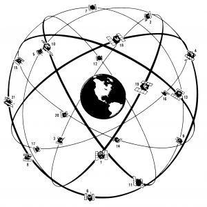
Following from these new navigation technologies, the final project examined in After the Map is the now-ubiquitous GPS. In the final chapter of his book, Rankin explains the unlikely rise of GPS within the American military bureaucracy. While various agencies—especially the Navy, the Department of Defense, and the civilian NASA—could agree on the benefits of a universal radionavigation system that would work anywhere in the world, the three actors had different needs. Early attempts at satellite navigation systems were often designed primarily for branch-specific tasks—helping Polaris submarines, for example. Other Navy systems involved ongoing political headaches. In the case of the Omega system, for example, the huge ground transmitters sometimes had to be moved in response to political pressure or instability—from Panama to Trinidad to Liberia—and there was major grassroots pushback in Australia.
GPS, in contrast, emerged out of the Department of Defense, and was altogether more ambitious, both technically and politically. Rankin explains the basic principle:
each orbiting satellite continually broadcasts a signal giving its location and the time when the signal was sent. Since the signal travels at roughly the speed of light, calculating the precise distance between the satellite and a receiver just requires knowing how long the signal took to reach the earth. But because GPS only uses one-way communication, this is only possible if all GPS clocks, on the satellites and in the receiver, are synchronized within only a few nanoseconds, since a time error of just one millisecond would mean a coordinate error of nearly three hundred kilometers.
The solution was to equip each GPS satellite with an atomic clock (accurate to about three seconds over a million years) and to always have at least four satellites in view from any point on earth. Because the clocks in most receivers are not nearly as accurate as those in space, these four satellites are used to solve for four unknown values: three for distance and one to synchronize receiver time with satellite time.
While it's tempting to marvel at the engineering triumph and take its success as a foregone conclusion, bureaucratic infighting complicated the design of GPS and political buy-in from different institutional actors was not easily won. "The essential dilemma of GPS was that it had the potential to be useful for everyone, but it was required by no one," explains Rankin. Ultimately, key actors within DOD ensured the program's survival by advocating a "go for broke" approach: a system that would solve all the problems of all key stakeholders, and also be able to solve problems that did not exist in the mid-1970s (for example, new more precise smart weapons). This was a risky and expensive gamble that was altogether unpopular outside the DOD. The project, for example, was subject to major budget cuts in the early 1980s. Huge sums were being invested into an ideal system, but with few stakeholders particularly interested in its success.
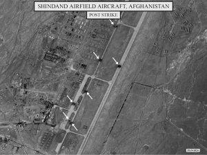
Yet outside shocks kept the process moving. When the Soviet Union shot down a Korean Airlines flight that had veered off course into Soviet airspace—killing a US Congressman on board—President Ronald Reagan vowed greater support for the program. Steps were taken by the early 1990s to use GPS as the standard for international civilian aviation, making it an open-access, dual-use system used by civilian airliners as well as the military. It also allowed for dramatic military successes during the Gulf War. Normally, armies would have struggled to maintain formation while navigating through the featureless deserts of southeastern Iraq. Iraqi dictator Saddam Hussein's armies counted on this fact and expected to engage coalition troops along better-mapped axes running from Kuwait to central Iraq. But GPS-armed US troops were able to sweep through the desert to trap Saddam's armies and end the war in one blow. The logic of the grid—with all of its implications for weaker states' sovereignty—was brutal, as GPS allowed users "to replace a local system of (nonexistent) physical landmarks with a new local system of electronic coordinates."
The advent of GPS meant not only a new kind of navigational hegemony for the USA but also, Rankin argues, a new kind of "pointillist" geoepistemic mapped on to the globalism of UTM. When he was looking through his sources, Rankin explains, "I started to look at the first uses people had for GPS. What were they doing, and what did they care about? And what I found wasn't things like driving directions or tight integration with digital maps. Instead what early users wanted was secure points. They wanted to be able to set a waypoint, and then later get back to their waypoint. Or geologists wanted to put a stable point on an island and track its drift due to plate tectonics over time. Sifting through dozens of journal articles and technical reports, the core theme was the need for stable reference points."
Points, in other words, had replaced even the grid as the most important optic for processing space. "That's even what the blue dot on our cell phones is about," says Rankin. "It locates us as a point, and it allows us to connect ourselves to other points. The stability of points is the crucial thing." Whereas mid-century aviators would navigate with grid lines printed prominently on their maps, now our GPS-equipped phones simply place us as points, and the grid disappears.
As Rankin concludes in a series of open questions at the end of After the Map, what GPS means for state sovereignty is not yet settled. When states signed up for UTM, they knew they were buying into a US-designed system that could easily be militarized. The only "customizability" of UTM, so to speak, resided in its applicability for national development programs, offshore surveys, and international boundary treaties. On a smaller scale, UTM systems could be "hacked" (colloquially speaking) by hikers and outdoor enthusiasts. But the system has remained relatively close to its US military roots.
Whether the story is the same with GPS is less clear. "GPS is useful for normal, everyday activities in ways that UTM just isn't. When taxi drivers want to move around Bangkok, they use GPS. And I'm not so sure that they're only participating in a US military project when they do so." And with increasing use of GPS for civilian aviation, "the US military can't just turn it off—thousands of people would crash. Much of this has happened against the military's wishes, and the core point is that GPS really is a hybrid system." After the Map leaves it an open question whether systems like GPS give greater proportional advantage to "local" uses over the "global" uses of the US military. For example, how do we weigh the bottom-up, GPS-driven countermapping of natural-disaster sites or informal settlements against the precision bombing of air bases during the 2001 invasion of Afghanistan? But even as GPS throws into question the importance of national borders today, what remains clear in all cases is the enduring relevance of territory, albeit constituted and engaged in novel ways through the pontillist geoepistemic of GPS.
As our conversation approaches its end, we ask Rankin about the projects he has on his desk now that After the Map has been successfully guided to print. One is a methodological book about mapping at the juncture of digital humanities, spatial history, and visual communication. Ever since he started Radical Cartography, Rankin notes, "I've been trying to think conceptually about maps and diagrams and the argumentative work they can do." In this book, which draws on research he has been collecting for the past several years, Rankin says he hopes to engage a range of questions: "How do we actually do our work spatially? How are we using mapping to advance our arguments? How can we use maps to engage academic and non-academic audiences at the same time?" As anyone who has ever dipped their feet into digital humanities or mapmaking will know, these are far from simple questions. This first project, Rankin notes, has a relatively short time horizon—perhaps a couple of years.
A bigger project altogether is his anticipated second major research project, which Rankin describes as "a spatial history of the environmental sciences." Rankin notes that too often, histories of environmental thinking are told without any attention to the actual techniques used to generate environmental knowledge. Rankin seeks to correct this by exploring how spatial knowledge is created about the skies, waters, forests, and other parts of the planet defined as "the environment." "For example," Rankin explains, "right now I'm interested in spatial modeling and how a hodgepodge of diverse measurements are combined to create a smooth-looking map. Or how satellite measurements are used to create images that look like photographs, but aren't. When we confront an environmental dataset, what exactly are we seeing? How did this knowledge come into being, and how did it become spatial? What assumptions are embedded within it?"
Beyond simply providing a useful history of these techniques, Rankin hopes to demonstrate the transnational lives of many tools used for the environmental sciences today. He notes that "the article that I'm working on right now starts with South African gold mining in the 1950s, but their techniques are picked up by French engineers in the 1960s and are used in the environmental sciences around the world by the 1980s. There's also someone in Russia developing similar techniques in meteorology, and his work gets picked up in Jerusalem and is later deployed in all the meteorological systems in the West. Today, these same algorithms are available as one-click solutions everywhere from soil management to global warming."
Yet more than just making the observation that such techniques were developed transnationally, Rankin's account will revise embedded clichés about the relationship between ecology and capitalism. "There's a strong sense that environmental thinking," says Rankin, "is divorced from capitalism, or opposed to capitalism somehow. But even in just this one case, we see how new kinds of environmental knowledge come directly from mining, and of course weather modeling was heavily supported by the US Navy. I'm still interested in many of the same players—military, commercial, and academic—that readers will encounter in After the Map."
While research on the second project and a busy teaching schedule stand to occupy a fair chunk of Rankin's schedule for the next several years, he still finds time to engage with recent work in several fields. When we ask him what he has been reading recently, he notes that much of his recent reading time has been devoted to understanding the legacy of the neo-Marxist geographic theory of the 1970s. "Much excellent spatial history is anchored in the work of Henri LeFebvre and David Harvey," he notes, "but their approach leaves a lot of questions unasked." Given how many other branches of academia have moved on from the neo-Marxist intellectual project, Rankin is trying to understand the enduring appeal—and possible responses to—the work of the aforementioned scholars.
Much of this is part of a broader intellectual re-tooling for the his spatial history of the environmental sciences, but beyond that, Rankin notes that he has enjoyed the work of Northwestern University historian (and Global History Forum guest) Daniel Immerwahr. Immerwahr's first book, which we discussed with him for the Global History Forum, focused on the history of community development as a part of U.S. modernization efforts in the Third World. However, Immerwahr's ongoing research on the history of the United States's "hidden" or post-territorial empire is what Rankin has found most generative recently. He also highlights the work of Rachel Rothschild, a former Yale PhD now at New York University, whose work explores the history of transnational acid raid pollution during the Cold War. Both of these projects, like Rankin's, combine "tight empirical work" with attention to the politics of space and how space was negotiated, whether within the framework of U.S. hegemony or Cold War Europe.
Our conversation with Rankin may not allow us to look at the GPS in our pocket, or its friendly bulging blue dot, in the same way again. The very fact of using GPS may mean that we are all, in some sense, invested in the military infrastructure of the American global project. Unless we all start drawing our own maps, we are likely to be unable, as are most states today, "to claim exclusive authority over the knowledge they rely upon" for our daily spatial existence. But as Rankin's account shows, there are plenty of ways that individual users can appropriate GPS for their own ends. Further, the very depth and breadth of GPS's penetration may make it a system where its makers and operators can never simply shut it off, so manifold are its uses. Users, communities, and states can respond by creating new tools or adapting old ones, but only with a historically grounded sense of the geoepistemic stakes of their choices.
Works like Rankin's represent a crucial intervention for achieving that kind of awareness, and we thank him both for authoring After the Map as well as participating in this installment of the Global History Forum.